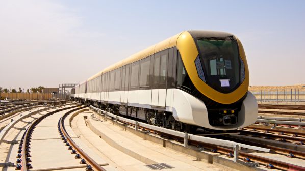
Riyadh, the capital city of Saudi Arabia, has undergone a remarkable transformation in its public transportation infrastructure with the introduction of the Riyadh Metro project. This ambitious endeavor stands as one of the world’s largest urban transport initiatives, aimed at alleviating traffic congestion and enhancing the daily commute for millions of residents and visitors alike.
Overview of the Riyadh Metro Project
The Riyadh Metro project is a monumental undertaking, boasting the title of the world’s largest turnkey metro project. With an estimated cost of $23 billion, it encompasses the construction of six lines spanning a total length of 176 kilometers and featuring an impressive network of 85 stations. Scheduled to open in February 2019, this project represents a significant milestone in the development of Riyadh’s public transportation system.
Design and Features of Metro Stations
The metro stations within the Riyadh Metro project are meticulously designed to cater to the needs of passengers while embodying modern architectural excellence. These stations are strategically located at key points throughout the city, including major intersections with other modes of transportation such as buses, making them easily accessible to commuters.
Each station is thoughtfully equipped with amenities to enhance the passenger experience, including shopping malls and parking facilities. Moreover, the stations prioritize passenger safety and security, featuring advanced surveillance systems, early warning mechanisms, fire extinguishers, and robust communication infrastructure to ensure a secure and comfortable journey for all travelers.
Comprehensive Overview of Metro Routes
Line 1 (Blue Line)
Line 1, also known as the Blue Line, traverses the north-south direction along prominent thoroughfares such as Olaya and Batha streets. Stretching over a distance of approximately 38 kilometers, this line comprises 22 stations, including four transfer stations connecting with Lines 2, 3, 5, and 6. While most of Line 1 operates underground, certain sections are elevated to optimize connectivity across the city.
Line 2 (Red Line)
The Red Line, or Line 2, operates in the east-west direction along King Abdullah Road, linking King Saud University with the eastern sub-center. Spanning a length of about 25.3 kilometers, this line features 13 stations and facilitates seamless transfers with Lines 1, 5, and 6 at designated interchange points. Line 2 primarily operates on a raised strip within the median of a planned freeway, ensuring efficient travel across Riyadh.
Line 3 (Orange Line)
Line 3, also referred to as the Orange Line, extends east-west along Al–Madinah Al Munawwarah and Prince Saad Bin Abdulrahman Al Awal Roads. With a total length of approximately 40.7 kilometers, this line comprises 20 stations, including two transfer stations with Lines 1 and 6. The route encompasses elevated, underground, and at-grade sections, offering diverse travel experiences to passengers.
Line 4 (Yellow Line)
Line 4, known as the Yellow Line, provides direct access to King Khalid International Airport from the King Abdullah Financial District. Covering a distance of around 29.6 kilometers, this line features eight stations, including three shared stations with Line 6, and enables transfers with Lines 1 and 6 at a designated interchange point. The route combines elevated and at-grade alignments to ensure swift connectivity to the airport.
Line 5 (Green Line)
The Green Line, or Line 5, operates underground along King Abdulaziz Street, connecting the King Abdul Aziz Historical Centre with the Riyadh Airbase before intersecting with King Abdullah Road. Spanning approximately 12.9 kilometers, this line comprises 10 stations and facilitates transfers with Lines 1 and 2 at designated interchange points. Line 5 offers a seamless commute through the heart of Riyadh’s urban landscape.
Line 6 (Purple Line)
Line 6, the Purple Line, follows a half-ring trajectory starting at the King Abdullah Financial District, passing by Imam Mohamed Bin Saud University, and concluding at Prince Saad Ibn Abdulrahman Al Awal Road. With a length of approximately 29.9 kilometers, this line features eight stations, including three shared stations with Line 4, and enables transfers with Lines 1, 2, and 3 at designated interchange points. Line 6 predominantly operates on elevated tracks, providing panoramic views of the cityscape along its route.
The Riyadh Metro project stands as a testament to the city’s commitment to sustainable urban development and efficient public transportation. With its extensive network of stations and routes, the metro system offers a convenient, safe, and environmentally friendly mode of travel for residents and visitors alike. As Riyadh continues to evolve as a global metropolis, the Riyadh Metro project serves as a cornerstone of its transportation infrastructure, facilitating seamless connectivity and enhancing the overall quality of life for its inhabitants.

